DAY 2 / Wednesday, 12 June: Deep Dive Discussion
Track: Applications
Session Highlight
View RecordingPoints of Discussion
- How human-machine teaming improves decision-making processes
- Importance of the network effect in AI systems for rapid information sharing
- Balancing human control with machine autonomy to maintain accountability
- Fusion of real-time machine data with human insights to enhance mission outcomes
- Emerging technologies that could further enhance sensor-to-shooter links
Lt Gen Sanjay Verma
Consultant
DRDO
Superannuated on 30 Sep 20 as the Director General Weapons & Equipment from ARMY HQs, New Delhi wherein Lt Gen Verma steered a large team with the focus extending across the entire spectrum of planning and acquisitions through outreach to Indian as well as Global Industries, R&D Facilities, Quality Assurance and associated National and International bodies. He is a Consultant with DRDO. He is a Fellow of the Institution of Engineers and is an Advisor/Subject Expert with the UPSC. He is also an Adjunct Faculty at IIT Delhi. He is an avid sportsperson and paratrooper. Awards received include: Param Vishist Seva Medal Ati Vishisht Seva Medal, Vishist Seva Medal (VSM) Bar to Vishist Seva Medal Eminent Engineers Award IIE.

Brig AS Nagra
Geospatial Expert
Brigadier A S Nagra (Retd) holds an HONOURS degree in Electrical Engineering and completed postgraduate technical courses specializing in Electronics, Radars, and Anti-Tank Missile Systems.
He retired from the Indian Army after 33 years of distinguished service, during which he gained extensive experience in developing and exploiting Automated Battlefield Surveillance Systems within Network Centric Warfare environments. Brig Nagra has a deep expertise in secure and real-time satellite-based sensor-to-shooter links. He has integrated these advanced systems across various terrains and conditions.
An active contributor to technical literature on Network Centric Warfare Systems, GIS, and Military Logistics, Brig Nagra regularly participates in national and international seminars. His expertise will significantly enrich the discussions at the Indo-Pacific Geo Intelligence Forum 2024.

Saurabh Rai
CEO
Arahas

Krishna Reddy
Business Development Manager
KaleidEO
Session Highlight
View RecordingPoints of Discussion
- Role of real-time data and situational awareness provided by drones
- Integration of AI and machine learning for autonomous operations
- Role of drones in asymmetrical warfare and counterterrorism operations
- Technological vulnerabilities such as hacking and electronic warfare
- How drones enhance the decision-making process for ground troops and commanders
Maj Gen Abhay Dayal, VSM
Ministry of Defence
Maj Gen Abhay Dayal, Vishishth Seva Medal, Additional Director General Technical (Army), is an alumnus of Indian Military Academy, Dehradun. His career highlights include command of a Medium Artillery Regiment equipped with Bofors Guns, a Mountain Artillery Brigade in the Eastern Sector, an Infantry Brigade in the Western Sector and an elite Mountain Strike Infantry Division in the Eastern Sector. His staff assignments include tenures as a Brigade Major of a Mountain Brigade, United Nations Military Observer in Democratic Republic of Congo, Colonel General Staff of a RAPID division in the Western Sector. His instructional appointments include Instructor in Gunnery at the School of Artillery, Devlali and as Colonel Directing Staff at the College of Defence Management, Secunderabad, besides two tenures at the Integrated Headquarters of MoD (Army), New Delhi.
He is currently holding the prestigious appointment of ADG Acq Tech (Army), MoD, dealing with Capital Acquisition Cases of weapons and equipment for the Indian Army. In the field of Capital acquisition, he has over seven years of experience.
For his distinguished service, he has been awarded Vishisht Seva Medal by the President of India and General Officer Commanding in Chief Commendation of Central Command and Western Command, twice.
Cdr Pankaj Srivastava
National head
Mahindra Defence Systems Limited
Pankaj is a veteran of the Indian Navy and the Nationa l Head Cyber
Defence and Forensics of Mahindra Defence System Limited (Division
Homeland Cyber Security) He is an accomplished leader with
experience in the fields of Defence and Homeland Cyber Security
industry and is part of the company which has become one of the
leading providers of Defence Security solutions in India.
With over 25 years of experience, he has held several leadership
positions within Indian Navy and now in the Mahindra Group He has
been part of numerous prestigious projects and is recognized for his
exceptional leadership skills and was awarded multiple
commendations by Vice Chief of Navy Staff as well as from
Commander in Chief, Western Naval Command.
His leadership style is characterized by out of box thinking and
customer focused approach This approach has enabled him to excel
in various areas, including operations, business development, forming
strategic partnership collaborations and creating innovative tech
solutions to address customer needs.
He has been associated with nearly all the facets of business i e
operations, training, procurement, Supply Chain, maintenance and
Planning.
He has been part of Acquisition Wing of Ministry of Defence and has been
instrumental in various Capital Acquisitions as well as in formulation of
Defence Acquisition Procedure 2020.
Pankaj holds key qualifications, including an engineering degree with
distinction, a Marine Engineer certification from Indian Naval Institute, and a Master's in Information Management from Jamnalal Bajaj Institute of Management, Mumbai He is also a Certfied Corporate Director from Institute of Directors.
Dr Ravi Kumar
RCI
DRDO
Rohit Srivastava
Indian Defence Industries
Rohit Srivastava is author, analyst, editor, consultant with over 15 years of experience in the defence and strategic affairs. He currently edits https://indiandefenceindustries.in/ and runs a consultancy firm RS Media and Consultants Pvt Ltd. He has published articles in various national and international journals and presented papers in international seminars on strategic affairs and defence business.

Sajal Gupta
Business Head
Indo Wings

NK Mishra, IPS
Former DGP Sikkim
Mohsen Shahedi
DIG
NDRF

Vinay Babu
Vice President
Hexagon

Dheeraj Mehra
CEO
Micronet
Devinder Chawla
Partner
iGeo Consultants
Experienced Air Force Veteran with proven track record of working in Leadership roles in Geospatial, Information Technology Projects and HR. Space and satellites excite! Skilled in Business development, Market strategy, Communication, Labor Relations, Satellite, Risk Management, and Data Analysis. Passionate for Artificial Intelligence and Machine learning.Strong professional graduated from ISRO.
Yetender Singh Negi
Subject Matter Expert
SATPALDA
Having Geospatial background in academics and 5 years of industrial experience in geospatial domain, I am a subject matter expert at SATPALDA working and promoting remote sensing data sets and processed digital maps for disaster management.
Session Highlight
View RecordingPoints of Discussion
- Importance of Geospatial Technology in National Security
- Government initiatives and policies supporting geospatial technology
- Developing robust frameworks for data security and privacy
- Improved decision-making capabilities for security agencies by monitoring and managing border regions
- Enhancing capabilities and expanding applications of geospatial technology
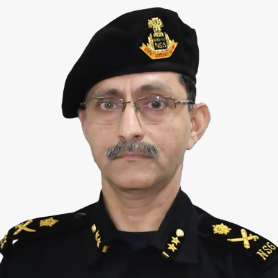
Maj Gen Praveen Chhabra, VSM
IG(Ops)
NSG
Major General Praveen Chhabra, Vishisht Seva Medal, an alumnus of National Defence Academy and recipient of the President's Gold Medal from Indian Military Academy was commissioned into Armoured Corps in Jun 1990. The General Officer Commanded an Independent Armoured Brigade from 2016 to 2018 and a Mountain Division from 2021 to 2022.
He is a graduate of the Defence Services Staff Course Wellington, Higher Defence Management Course from College of Defence Management, Secunderabad, National Defence Course from National Defence College, New Delhi and attended the Armour Officers Advance Course from US Army Armour School, Ft Knox, USA.
He has vast operational experience of having served in OPERATION RAKSHAK in Punjab and Jammu & Kashmir, OPERATION SNOW LEOPARD in Ladakh and was awarded the Wound Medal in 1995. In his staff appointments; as a Major he was posted as Chief of Operations of an Independent Armoured Brigade, as a Colonel he was Chief of Operations & Intelligence of an Infantry Division and Director of International Defence Cooperation in Army HQ. As a Brigadier he led the development of an automated 'Decision Support System' at the Directorate of Information Systems and later handled HR Management in Military Secretary's Branch of Army HQ. Amongst his foreign assignments, he was a Military Observer in UN Mission in Eritrea and Defence Advisor at the High Commission of India at Malaysia and Burnei. He has had two tenures as an Instructor, first at the National Defence Academy and later at School of Armoured Warfare, Armoured Corps Centre & School, Ahmednagar. The General Officer took over as Inspector General (Operations), National Security Guard on 19 Oct 2022.
He has been conferred with Vishisht Seva Medal, Chief of Air Staff Commendation, Chief of Army Staff Commendation, General Officer Commanding-in-Chief (Northern Command) Commendation and Director General NSG Commendation during his service.

Krishna Rao
General Manager - Presales
Esri
Krishna Rao TVB, a seasoned Technology Thought Leader and Consultant, with over 26 years of experience in geospatial technology and digital transformation. He has spearheaded enterprise GIS solutions for Government, Defence, Utilities, and Smart Cities across India, driving business worth INR 200 Crores. Krishna excels in solution architecture, technical support, and pre-sales management, and is recognized for his strategic leadership and innovation in GIS technologies. He has held senior positions at ESRI India and Intergraph Middle East, and his expertise includes location intelligence, GIS datasets, and remote sensing. Notably, he has received multiple awards and published several papers on GIS applications.

V Vijay
Director
Omega Analytics Private Ltd
V Vijay is the founder of Omega Analytics, a Bengaluru based company providing analytics and technology solutions for planning, design and construction of transportation infrastructure. Under his leadership, Omega Analytics has emerged as a leading consultant in several areas of Transportation Systems Engineering and related Information Technology domains - Feasibility Studies, Hydrological Investigations, Topographic Surveying, Project Financial & Economic Analysis, Data Analytics, Geographic Information Systems, and Civil Construction Information Systems.
Vijay has a B Tech from IIT Bombay, MBA from IIM Bangalore and MSc Finance from the University of Strathclyde, Glasgow, United Kingdom. He worked in the investment banking, asset management and banking technology sectors in India and Europe prior to promoting Omega Analytics. He is also an active member of the Asia Centre Bangalore, a defence and security research think tank. Vijay is a Research Associate of the International Institute of Information Technology, Bangalore (IIITB) and a guest speaker at the Indian Railway Institute of Civil Engineering, Pune.
Amit Seymour
CEO
Satpalda
Lt Gen Vinod Khandare, PVSM, AVSM, SM
Principal Advisor
Ministry of Defence
Lt Gen Vinod G. Khandare, PVSM, AVSM, SM (Retd) is currently serving as the Principal Adviser in the Ministry of Defence. He retired from active military service on 31 January 2018 and was the Military Advisor to the National Security Council Secretariat of India at the Secretary level from 2018 to 2021. In his final active military appointment, he served as both the Director General of the Defence Intelligence Agency and the Deputy Chief of Integrated Defence Staff for Intelligence from November 2015 to January 2018.